


 Log in
 Log out
M7.1 Japan
Status: Active
| Type of posting | Posting date(EST): | Summary | Downloads |
|---|---|---|---|
| Custom Events | 8/2/2026 9:00:00 PM |

|
|
| Similar Stochastic Events | 7/29/2026 8:00:00 AM |
|
|
Custom Events | Summary
Posting Date: August 2, 2026, 9:00:00 PM
Verisk estimates that insured losses to properties from the July 28 magnitude 6.8 (per the United States Geological Survey) earthquake that struck near Kumamoto City on Kyushu Island, Japan, will be between JPY 220 billion (~USD 1.4 billion) and JPY 340 billion (~USD 2.1 billion).
ALERT™ subscribers can download Touchstone® and Touchstone Re™ custom event sets of five scenarios for this event, a Touchstone-ready shapefile of the estimated ground motion for the median scenario, and loss-based similar stochastic events from the Downloads tab on the ALERT website. The information provided herein is strictly confidential and is solely for the use of our clients; disclosure to others is prohibited unless noted in your software license.
Modeling Assumptions
Verisk’s loss estimates are gross of government recoveries (i.e., prior to the application of the Japanese Earthquake Reinsurance scheme). They explicitly capture damage from ground shaking and liquefaction. Losses are dominated by shake damage in Verisk’s scenarios, with a very small contribution from the other modeled sub-perils. Note that Verisk’s estimates are based on assumptions about take-up rates in Japan (the percentage of properties actually insured against the earthquake peril), which are uncertain. The range in loss estimates also reflects uncertainty in the slip distribution on the fault plane, modeled ground motion, and damage estimation. The assumed exchange rate is 1 JPY = 0.0062 USD.
Two Touchstone Re event sets have been provided with this posting, reflecting different assumptions about policy conditions on our industry exposure database. One provides a “100% limits” view, and the other is the “Industry Policy Mix” (IPM). The IPM perspective in this posting includes residential line of business losses which are gross of government reinsurance recoveries and as such can be used to generate the industry loss range quoted above.
Verisk’s insured loss estimates include:
- Insured physical damage to onshore property (residential, commercial/industrial, mutual), both structures and their contents, and from ground shaking and liquefaction.
Verisk’s insured loss estimates do not include:
- Losses to uninsured properties
- Losses due to fire following
- Losses to land
- Losses to infrastructure
- Losses to automobiles
- Business interruption losses, both direct and indirect
- Workers’ compensation losses
- Losses to civil engineering (railway) risks, marine cargo and marine hull risks, aviation risks
- Risks, Transit warehouse risks, movable all risk, and personal accident risks
- Loss adjustment expenses
- Losses from non-modeled perils, such as landslide
- Demand surge—the increase in costs of materials, services, and labor due to increased demand following a catastrophic event
Event Overview
According to the United States Geological Survey (USGS), the July 28 M6.8 earthquake south of Kumamoto, on the island of Kyushu in southwest Japan, occurred as the result of shallow strike‑slip faulting. Focal mechanisms indicate that the slip took place either on a left‑lateral fault striking northwest or on a right‑lateral fault striking northeast. Although the earthquake occurred several hundred kilometers northwest of the Ryukyu Trench, where the Philippine Sea plate begins its northwestward subduction beneath Japan and the Eurasia plate, the shallow depth and faulting style indicate that this event occurred on a crustal fault within the upper Eurasia plate. At this location, the Philippine Sea plate converges with the Eurasia plate toward the northwest at a rate of 58 mm per year.
Most seismicity in the Kyushu region is associated with the deep subduction of the Philippine Sea plate. However, a deadly earthquake sequence struck this region in April 2016. That sequence included two foreshocks, M6.2 and M6.0, followed one day later by a M7.0 mainshock. The foreshocks to the April 2016 M7.0 event caused at least nine fatalities and injured more than 800 people, while the M7.0 mainshock killed at least 40 people and injured over 2,000. Approximately 12,000 houses were damaged or destroyed by the 2016 M7.0 earthquake, and the Aso Ohashi Bridge in Minamiaso collapsed into the Kurokawa River due to a landslide triggered by the quake.
Damage and Impacts
The magnitude 6.8 earthquake, which struck at 4:27 p.m. JST at a shallow depth of about 10 km, caused widespread structural damage across Kumamoto Prefecture, with the strongest shaking (“shindo” 7) recorded in Uki City and Hikawa Town. In Hikawa Town alone, 125 houses were completely destroyed and more than 800 buildings in total were confirmed damaged, with officials warning the toll could rise further. The deadliest single incident was at AEON Mall Kumamoto in Kashima Town, where part of the second floor collapsed before a powerful explosion, believed to have been triggered by a gas leak, tore through the complex, blowing out walls and exposing steel framework; the mall's death toll has since risen to seven. A separate fatal incident occurred at a Nippon Paper Industries mill in Yatsushiro City, where a collapsed chimney trapped workers. Other reported building damage included the collapse of the 19th-century Yatsushiro-gū shrine's worship hall and a section of a bridge, injuries at a nursing home in Hikawa from a collapsed wall, and a crane collapse in Kōsa that killed a Vietnamese national. Kumamoto Castle, still under long-term restoration after the 2016 earthquakes, sustained additional damage to its stone walls.
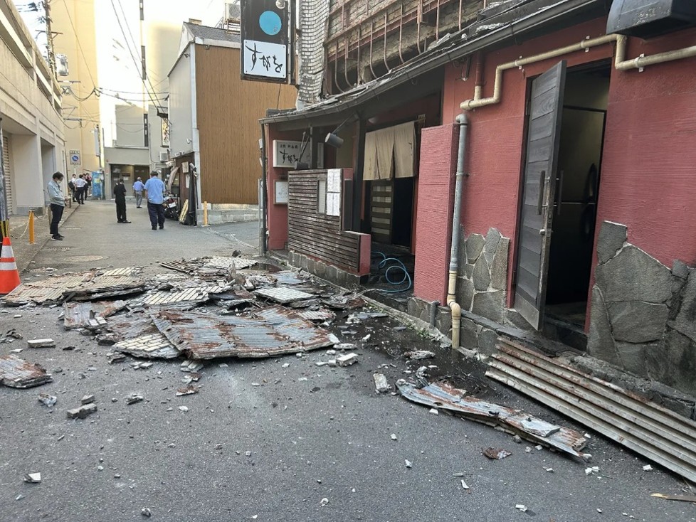
Damage to an exterior wall in Kumamoto City (JIJI Press/AFP via Getty Images)
Transportation infrastructure was heavily affected. Highway overpasses on the Kyushu Expressway in Yatsushiro sustained significant damage, and the pedestrian portion of a bridge collapsed in the same city, with road closures in place on 13 sections of two expressways as of the following morning. JR Kyushu suspended all rail lines, including the Kyushu Shinkansen, with a freight train derailing near Yatsushiro Station and passengers suffering bruises aboard a Shinkansen train at Shin-Yatsushiro; Shinkansen service between Hakata and Kagoshima-Chuo remained suspended, with only limited segments restored by July 30. Kumamoto Airport closed its runway for inspection, canceling all domestic flights that day, and 14 flights were still cancelled the following day. Ground deformation was also recorded, including a reported 0.84-meter shift at a geographic reference point in Yatsushiro and surface ruptures along the Hinagu Fault. Around 48,000 households lost electricity, and mobile service was disrupted in some areas due to power failures and damage to transmission facilities.
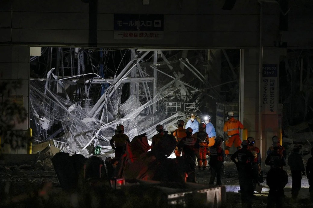
Rescue operations at the AEON mall (KYODO, via Reuters)
Kumamoto's status as a major semiconductor and automotive manufacturing hub, accounting for roughly two-fifths of regional industrial output, meant the earthquake had outsized economic ripple effects. TSMC's Japanese subsidiary JASM evacuated staff and reported no damage after inspections, and TSMC noted its Kumamoto fab represents less than 3% of its total production capacity. Renesas Electronics halted operations at two Kumamoto plants after finding fallen ceiling panels, wall cracks, and water leaks, while Sony Semiconductor Manufacturing's Kumamoto Technology Center, the world's largest image sensor plant, remained suspended as of July 29 while the company assessed building and equipment damage. Tokyo Electron's Kyushu plant, which holds a large majority global share of certain key semiconductor equipment, was also forced to halt operations, raising concerns given that a comparable 2016 quake took Sony's plant roughly three months to fully recover. Toyota separately suspended production at three plants in neighboring Fukuoka Prefecture as a precaution.
Beyond manufacturing, the quake disrupted daily life and services broadly: officials instructed roughly 300,000 residents to evacuate to shelters, hospitals in Yatsushiro and Kumamoto City took in dozens of injured patients, and local rail operators including the Minamiaso Railway and Kumamoto Electric Railway suspended service. The final tally of damaged structures and economic losses was still being compiled at the time of this summary.
This is the final planned ALERT posting for this event. Please contact your Verisk representative with any questions.
Custom Events | Downloads
Posting Date: August 2, 2026, 9:00:00 PM
The information provided herein is strictly confidential and is solely for the use of Verisk clients; disclosure to others is prohibited.
Simulated Event Set
These simulated event sets contain five scenarios of the July 28, 2026 Kumamoto earthquake. For Touchstone Re, there are two event sets - one representing an "Industry Policy Mix" loss perspective and the other representing policies paid at 100% Limits.
| Product | Version | Description | Download |
|---|---|---|---|
| Touchstone Re | Up to 13.x | Selected set of simulated scenarios |  |
| Touchstone | Up to 13.x | Selected set of simulated scenarios | |
Similar Stochastic Event IDs
These lists give event IDs taken from our stochastic catalog that have similar modeled industry loss footprints as the custom scenarios in the Simulated Event Set for this earthquake.
| Product | File Type | Description | Download |
|---|---|---|---|
| Touchstone / Re | Excel (xls) | Selected set of stochastic events, with Readme in Excel format | |
| Touchstone / Re | CSV (csv) | Selected set of stochastic events, formatted for import into Touchstone/Re | |
Additional Downloads
Additional downloads related to the posting are listed below. Please use the appropriate application to view these files.
| Title | File Type | Description | Download |
|---|---|---|---|
| Ground Motion Shapefile | .zip | A shapefile of the median custom event (by estimated industry loss) modeled ground motion | |
| Industry Losses | Excel (xlsx) | Estimated insured industry losses based on 2026 indexed insured take up rates and the Industry Policy Mix (IPM) perspective | |