First Posting | Summary
Posting Date: January 4, 2012, 12:30:00 PM
Windstorm Ulli is passing through Scandinavia and is expected to dissipate as it moves over the Baltic Sea today. A class 2 weather warning from the Swedish Meteorological and Hydrological Institute (SMHI) is still in force indicating the possibility of “danger to the public, causing major damage to property and major disruptions in essential services.”
Ulli was first recognized as a named low pressure system when it was located southwest of Newfoundland on December 31st making it the last named storm of 2011. Ulli brought heavy precipitation and high winds, causing widespread travel disruption across the UK and Europe. The system intensified significantly as it sped across the north Atlantic, eventually making landfall in Scotland with a central pressure of just 952mb.
Localized flooding remains a danger, and officials in the UK, Scotland, and Germany have issued flood warnings.
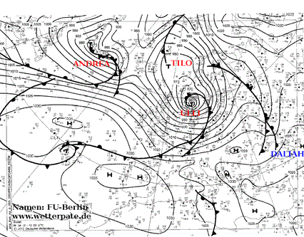 Figure 1: Cluster of low pressure systems currently passing through Europe
Source: http://www.met.fu-berlin.de/de/wetter/maps/anabwkna.gif
Meteorological Conditions
Figure 1: Cluster of low pressure systems currently passing through Europe
Source: http://www.met.fu-berlin.de/de/wetter/maps/anabwkna.gif
Meteorological Conditions
Ulli’s stronger than forecast winds have been blamed on the presence of a sting jet, a localized strong downdraft that can develop on the southern flank of an extratropical cyclone and bring cold, dry air from the mid-troposphere down to the surface. Sting jets generally cause intense, localized wind speeds, and this development may be responsible for the high gust speeds (of 106 mph) recorded in the North Pennines in Scotland. Maximum wind speeds in more heavily populated areas typically reached gust speeds as high as 80 to 90 mph.
Over the past few months, northern Europe has seen a number of significant storms pass through, beginning with Xaver and Yoda which impacted the region in late November. These were followed by Friedhelm in early December and subsequently by both Joachim and Patrick (Dagmar) in late December. This clustering effect of windstorms in Europe—storms following closely on the heels of one another—is a well-studied phenomenon and is explicitly accounted for in the AIR Extratropical Cyclone Model for Europe.
The northerly route of this season’s storms is unlike that of the previous two European winter storm seasons which saw only windstorm Xynthia impact central Europe in the winter of 2009/10. The reason for this northward shift in recent storm activity is due to the apparent changing North Atlantic Oscillation (NAO) from a negative to positive phase, as seen in Figure 2 below. It is well known that a positive NAO signal is correlated with higher storm activity in the Atlantic, northwest of the United Kingdom, and storms from this region affect northwestern Europe.
i
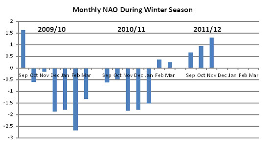 Figure 2: NAO 2009 – 2011
Source: http://www.cpc.ncep.noaa.gov/products/precip/CWlink/pna/nao.shtml
Building Stock
Figure 2: NAO 2009 – 2011
Source: http://www.cpc.ncep.noaa.gov/products/precip/CWlink/pna/nao.shtml
Building Stock
Residential building stock in the areas affected by Ulli is predominantly of masonry construction. For commercial exposures, however, the construction type is approximately 50% masonry with the remaining construction split between steel frame and reinforced concrete. Little structural damage to these construction types is expected for wind speeds of the order widely experienced from Ulli although damage to cladding, signage, and some isolated roof covering damage could occur.
Reported Impacts
The region affected by Ulli is similar to that of Windstorm Friedhelm, although Ulli’s wind speeds were generally lower. Disruption to travel was widespread as roads, bridges and rail lines were forced to shut down due to the high winds. Ferry crossings between Britain and Ireland and between Denmark and Norway were cancelled. Ulli caused massive power outages—of the same order to Windstorm Friedhelm in December—and approximately 90,000 households lost power during the storm.
Although structural damage is expected to be limited, there have been some reports of roof tile damage, including damage to the roof of the grandstand at Epsom. A brickwork façade in Sheffield crumbled, scattering rubble through the streets. In Hainault in London, a tornado uprooted a bus shelter and tore tiles from roofs, pummeling cars with debris. Throughout the region, uprooted trees and fallen branches are a major concern and caused a fatality in Kent when a car was crushed by a falling tree.
Forecast
The system passed into northern Germany on Tuesday night maintaining moderate wind speeds and the threat of flooding. Perhaps the greater threat, however, is yet another low pressure system currently tracking close to Ulli’s path. Windstorm Andrea is expected to pass over the UK on Thursday. In advance of the storm’s arrival, the Met office has issued yellow warnings for rainfall levels.
Andrea will be monitored closely as it develops and AIR will provide updates as warranted.
__________________________
i It has long been observed that anomalous monthly-averaged sea level pressure in a region spanning the central latitudes of the North Atlantic near the Azores is consistently out of phase with another region located at higher latitudes near Iceland (Barnston and Livezey 1987). For example, high pressure over Iceland is accompanied by anomalous low pressure over the Azores. The large-scale north-south dipole of anti-correlated pressures between these two centers defines the North Atlantic Oscillation (NAO)—a pattern that drives surface winds and wintertime storms from west to east across the North Atlantic, affecting the climate in Western Europe as well as in regions further east.
