
Hurricane Jova
Status: Closed
| Type of posting | Posting date(EST): | Summary | Downloads |
|---|---|---|---|
| Post Landfall 1 | 10/13/2011 10:45:00 AM |
|
|
| Landfall | 10/12/2011 8:02:00 AM |
|
|
| Pre-Landfall 2 | 10/11/2011 12:30:00 PM |
|
|
| Pre-Landfall 1 | 10/10/2011 10:30:00 AM |
|
Post Landfall 1 | Summary
Posting Date: October 13, 2011, 10:45:00 AM
After striking a sparsely populated stretch of Mexico’s Pacific coast on October 11 as a Category 2 hurricane, Jova weakened as it traveled inland towards the north, dissipating late last night over the state of Nayarit. Because it was a small storm and weakened to tropical storm strength within 12 hours of landfall, damage from Jova’s winds has been limited.
However, heavy rainfall, which began as Jova’s outer rain bands approached the coast prior to landfall and is finally subsiding after the storm’s dissipation, has caused serious flooding and landslides in parts of Colima and Jalisco. Mexico’s coastal mountains enhanced precipitation on the north and east sides of the storm. As the slow-moving storm came ashore, its counterclockwise flow of air was forced over the mountainous terrain, cooling in its ascent and forming clouds and precipitation.
Wind Observations and Rainfall Totals
The highest recorded wind speed was a 74 km/h (46 mph) gust in Manzanillo. However, this was located outside Jova’s 15-mile radius of maximum winds. It thus does not reflect the true maximum winds that were located in a very limited area around the eye of the storm at the time of landfall, which according to the National Hurricane Center was around 100 mph.
Initial reports from the Mexico National Weather Service indicate up to 37 cm (14.5 in) of rainfall in parts of Colima, and 10–12 cm (4-5 in) in other impacted areas, including parts of Chiapas, Jalisco, and Michoacán. These rainfall totals fall within the forecast range.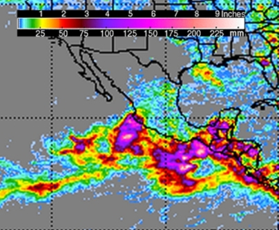 72-hour total rainfall, ending 10/13 0900 UTC. Source: NASA Tropical Rainfall Measuring Mission (TRIMM) satellite.