
Typhoon Ma-On
Status: Closed
| Type of posting | Posting date(EST): | Summary | Downloads |
|---|---|---|---|
| Landfall | 7/20/2011 11:00:00 AM |
|
|
| Pre-Landfall 1 | 7/18/2011 1:30:00 PM |
|
Landfall | Summary
Posting Date: July 20, 2011, 11:00:00 AM
Tropical Storm Ma-On made landfall in southern Tokushima Prefecture on Shikoku Island late Tuesday night local time. The sixth named storm of the season and the first to make landfall in Japan this year, Ma-On had maximum sustained winds of 120 km/h at landfall, making it a severe tropical storm on the Japan Meteorological Agency’s (JMA) intensity scale. The storm briefly reintensified to typhoon strength as it swept near southern Honshu before weakening again as it moved eastward out to sea.
As of the JMA’s 15:50 UTC advisory, Ma-On is located approximately 300 km south-southwest of Tokyo and is moving 20 km/h east-southeast, packing maximum 1-min sustained winds of approximately 105 km/h. The storm is expected to weaken gradually and make a turn to the northeast later this week.
The slow forward speed of the storm has created concerns of mudslides and flooding caused by prolonged heavy precipitation. The JMA has issued alerts for high waves and heavy rain for coastal portions of the Kinki, Tokai, and Kanto regions. Hundreds of flights have been canceled and widespread rail disruptions have been reported. 170,000 households lost power temporarily, and high waves have halted shipments at a few oil refineries.
Total rainfall has exceeded 1000 mm in some portions of the country, and there have been reports of flooded homes in Shiga, Kochi and Wakayama prefectures. In the town of Umaji in Kochi Prefecture, accumulated precipitation totaled over 860 mm on July 19, setting a one-day rainfall record according to the JMA. The figure below shows the 72-hour rainfall accumulation for Japan.
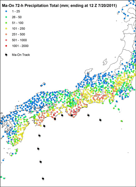 72-hour precipitation total (Source: JMA and AIR)