Update 2 | Summary
Posting Date: January 27, 2009, 4:00:00 PM
AIR Worldwide estimates insured losses in France from winter storm Klaus of between 350€ million and 700€ million. The strong extratropical cyclone (ETC) made landfall early Saturday morning in southwestern France and traveled east through southern France before exiting south to the Mediterranean coast less than twelve hours later. Klaus brought locally fierce winds in excess of 150 km/h (similar to a strong Category 1 hurricane) and torrential rains, causing building damage, flooding, as well as power outages and travel disruptions across southwestern France and parts of northern Spain.
Winter storm Klaus was a mid-latitude storm that formed on Thursday night in the subtropical North Atlantic, west of the Azores Islands. The system moved northeastward into the Bay of Biscay on Friday. Exhibiting a period of very rapid strengthening known as “explosive cyclogenesis,” Klaus’ central pressure dropped from about 1000 millibars late Thursday to a minimum pressure of 967 millibars on early Saturday morning. The storm quickly traveled over southern France at a speed of about 110 km/h.
Klaus was the most intense and damaging ETC to affect the region since Martin in December of 1999, which caused an estimated 2.5€ billion of insured loss in France at the time. While the maximum wind speeds from Klaus were in some cases higher than for Martin, Klaus’ footprint of damaging winds within France was restricted to the far south, while Martin produced wind damage over a larger portion of France. Also, because Klaus’ track was farther south than that of Martin, a greater portion of its most damaging winds occurred over water, sparing much of southeastern France from its strongest winds.
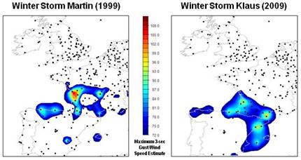
AIR’s meteorological team has determined that Klaus’ southern route was quite unusual. Historically, only about 6% of ETCs have moved south of Martin’s track, and amongst those storms, only 12% continued to move south of the Swiss Alps after exiting France. Most ETCs move to the north and east as they traverse Europe. The route that Klaus took over France’s border with Spain is expected to occur only about once every 10 years. The “jet stream”—a corridor of strong upper-level winds that guide the path of mid-latitude storms—was situated unusually far south before and during the passage of Klaus.
In France, where roughly half of the residential stock was built prior to 1970, unreinforced masonry construction is common. At the wind speeds recorded for winter storm Klaus, AIR engineers generally expect wind damage to be restricted to the envelope (outer shell) of the building, including the façade, the roof, chimneys, and windows. In southern France, roofs constructed of “canal tiles” are common; these terracotta tiles are not attached to the roof, but are instead arranged in an overlapping pattern that holds them in place, making them especially susceptible to wind damage. Significant structural damage can also occur to barns, greenhouses, and light metal structures such as warehouses.
Klaus caused significant damage to electrical and telecommunications lines, and hundreds of thousands of homes remain without service in France. Very large claims from utility companies are possible. Business interruption losses may be considerable depending on how long it takes for power to be restored. Also, France’s lumber industry was particularly hard hit by Klaus. French forestry groups reported that Klaus felled 60% to 70% of pine trees in parts of the southwest. The forests in this area, mostly privately owned, account for about a third of the country’s lumber production, but only a small percentage is insured against storm damage.
On Monday, French authorities declared a state of alert in eight departments in the south because of the risk of severe flooding. Flood damage is typically not covered in home insurance contracts, but government-backed compensation funds are available if the event is declared a natural catastrophe. Officials in the region have called for support from the EU Solidarity Fund to provide emergency aid. The French Federation of Insurance Companies, Fédération Française des Sociétés d’Assurances, has agreed to expedite the claims process and to extend the claims deadline.
AIR has deployed two post-disaster survey teams, which have already begun to gather damage information in the affected regions in southern France. Team 1 is surveying Bordeaux and the surrounding areas to the south and east. Team 2 is surveying Toulouse and areas to the east. Initial observations indicate damage levels as expected for this type of event. So far, portions of southeastern France have been surveyed. Damage in these areas is generally light and mainly restricted to roofs. Most homes in the area are Mediterranean-style buildings with low-pitch terracotta roofs. Tile damage has mainly been observed at the edges and ridges of roofs, which is expected at these wind loads.
Little to no damage has been observed to greenhouses and gas stations in the areas surveyed so far, indicating that high wind speeds were not observed in these areas. There are a few isolated high damage incidents, including a church and school building. A great deal of tree damage has been observed, but property damage from downed trees is not common. Minor damage in Perpignan is fairly widespread where some of Klaus’ highest winds were observed. The survey teams will cover another region of strong winds in the Bordeaux region out to the Atlantic coast.
The AIR extratropical cyclone modeling team has run the numerical weather prediction (NWP)-based AIR European Extratropical Cyclone Model with the latest meteorological data. AIR estimates insured wind losses in France for Windstorm Klaus at between 350€ million and 700€ million. Significant losses are also expected in Spain, a country that is not currently modeled by the AIR European Extratropical Cyclone Model.
