


 Log in
 Log out
Hurricane Isaias 2026
Status: Active
| Type of posting | Posting date(EST): | Summary | Downloads |
|---|---|---|---|
| Custom Events | 10/13/2026 12:00:00 PM |

|
|
| 10/12 Update | 10/12/2026 1:00:00 PM |
|
|
| Landfall SSEs | 10/10/2026 10:00:00 AM |
|
|
| Pre-Landfall SSEs #2 | 10/9/2026 10:00:00 AM |
|
|
| Pre-Landfall SSEs #1 | 10/8/2026 12:00:00 AM |
|
|
10/12 Update | Summary
Posting Date: October 12, 2026, 1:00:00 PM
Hurricane Isaias made landfall on the evening of Friday, October 9th near Destin, FL with a minimum central pressure of 971 mb and 105 mph maximum sustained winds. This was almost exactly 2 years after Hurricane Milton made landfall along Florida’s Gulf Coast, and it makes Isaias the first hurricane to make landfall in the U.S. since then. The landfall point in Destin was approximately 100 miles east of the Alabama-Florida border, which spared the Alabama coast the worst of the eyewall; officials in Orange Beach reported minimal damage and Mobile Bay experienced a “blowout” tide as strong northerly winds from Isaias drained the bay to 2.2 feet below normal.
In Florida, preliminary observations include a gust of 116 mph with a sustained wind of 91 mph at a WeatherFlow station near Santa Rosa Sound, a gust of 118 mph near Jay, a gust of 102 mph with a sustained wind of 62 mph at Pensacola City Hall, and gust of 100 mph at a WeatherSTEM station near Pensacola. These are unofficial reports, and there were likely higher, more localized winds in some locations where there was no instrumentation or where instruments failed. Related, our post-event wind analysis for Isaias from Verisk Weather Respond was shipped to Respond clients Saturday evening. The final wind field incorporated observations from 224 stations across the storm’s footprint.
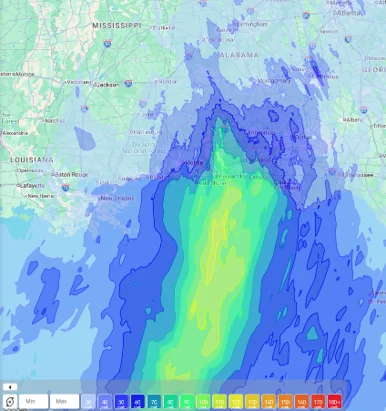
Verisk Weather Respond wind footprint (3-second gust) for Hurricane Isaias
As Isaias approached the Florida panhandle, the effects of the shear and dry air associated with the mid-latitude system pushing it began to be significantly detrimental. The storm became highly asymmetric, with the highest winds on the northern edge. The influences of the dry air and mid-latitude shear manifested into a strong wind draft on the western edge through Baldwin County, AL and Pensacola, FL during landfall, driving some of the aforementioned high wind gust observations.
Storm surge and heavy rainfall also produced significant coastal inundation, with a NOAA tide gauge at Panama City Beach measuring a water level 5.6 feet above mean high water around the time of landfall. Local reports indicate 2 to 3 feet of water in Fort Walton Beach, though observations were limited near the landfall location owing to evacuations so peak inundation will be better defined by post-event surveys. A Flash Flood Emergency was declared for southern and coastal Okaloosa County, including Destin and Fort Walton Beach, as rainfall rates of 2-4 inches per hour were observed. A rare high flash flood threat was issued by the Weather Prediction Center (WPC) for the Florida Panhandle, Big Bend, southern Georgia, and southeastern Alabama. By early on the 10th, rainfall totals had eclipsed the 1-foot mark in some locations; including 12.97 inches in Bellwood, Alabama and 12.46 inches in Defuniak Springs, Florida. Isaias has rapidly weakened after moving inland and transitioned into a post-tropical cyclone over Alabama early Saturday morning. Early indications from the flood Claims layer in our GEO product suggest that flood damage from this event appears very limited, and typically light in nature.
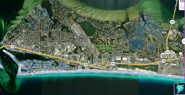
Pre-Event Surge and Flood Warnings (blue shading) around Destin, FL in GEO
In the Florida Panhandle, the damage was wind-driven and widespread. Reports indicate widespread tree and power line damage across the western Panhandle; the roof was torn off a Pensacola hotel and the boardwalk at a Destin beach was washed away. Hurricane-force winds tore the roof off a Pensacola hotel, the city’s mayor said the airport was damaged, a boathouse was destroyed in Destin, and part of a high-rise’s facade was torn away in Panama City Beach. Local reporting also describes the roof ripped off the Playa Blanca Apartments in Milton, a Pensacola gas station that lost its roof, destroyed pumps at a Shell station in Gulf Breeze, and downed trees on roads near Gulf Breeze High School. The Milton High School gymnasium was destroyed, with debris scattered across the campus, and one resident called the scene “pretty catastrophic.” One officials’ assessment was that the impacts were broad, stretching from the Alabama-Florida line to the far eastern Panhandle, not confined to the landfall county. As of Monday morning, about 175,000 customers in the storm’s path remained without power, per poweroutage.us.
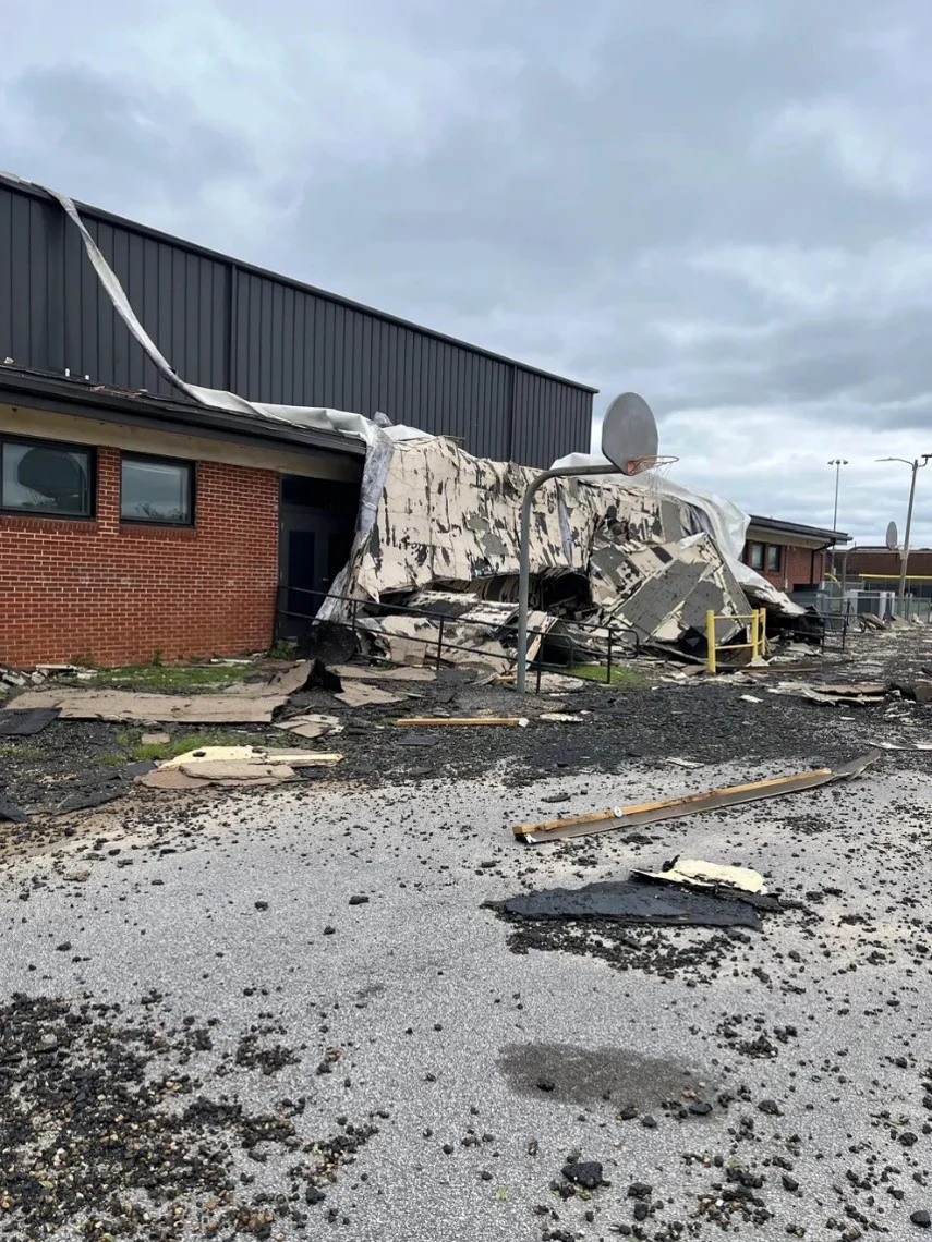
Damage to the Milton, FL High School gym (Tom MacLaughlin)
The storm’s effects in Alabama came mostly from tropical-storm-force winds and falling trees. Isaias pushed into Alabama with tropical-force winds, and damage was found in Escambia County, Alabama, on Saturday morning. Farther inland, Jefferson County emergency management reported multiple cases of trees damaging homes across the county, including one that fell on a house in the Birmingham area and killed a person. At least four deaths are linked to the storm: two in Florida and two in Alabama. In Escambia County, Florida, a woman died when a tree fell on her home, and a man died of carbon monoxide poisoning from a generator run in his garage; four of his family members were treated and are expected to survive. Surge damage appears limited so far. Despite storm surge warnings, several major coastal routes were open and clear of debris by Saturday morning.
Through our GEO event intelligence solution, we have been providing pre-event information, including the predicted path, predicted arrival times, cone of uncertainty, and later, confirmed track and confirmed arrival times, updated daily. We have also released Wind Speed Probability layers as well as a Potential Storm Surge layer. Additionally, we have provided an initial Exposure Layer, providing a quick snapshot of the impacted area. Finally, the Wind and Flood Claims Layers along with imagery of damaged areas have begun to arrive in the solution, and more will be added within the area of interest over the next couple of days as it becomes available.

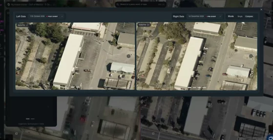
Assessing Location Level Damage in the GEO Platform
The Verisk ALERT team will release an insured industry loss estimate, event sets containing five scenarios of Hurricane Isaias for modeling in Touchstone and Touchstone Re, loss-based similar stochastic events, and shapefiles of the median modeled wind and storm surge footprints on Wednesday morning at 6:00 am EDT. Please reach out with any questions about this event or any of our event response and intelligence solutions.