


 Log in
 Log out
Hurricane Isaias 2026
Status: Active
| Type of posting | Posting date(EST): | Summary | Downloads |
|---|---|---|---|
| Custom Events | 10/13/2026 12:00:00 PM |

|
|
| 10/12 Update | 10/12/2026 1:00:00 PM |
|
|
| Landfall SSEs | 10/10/2026 10:00:00 AM |
|
|
| Pre-Landfall SSEs #2 | 10/9/2026 10:00:00 AM |
|
|
| Pre-Landfall SSEs #1 | 10/8/2026 12:00:00 AM |
|
|
Pre-Landfall SSEs #2 | Summary
Posting Date: October 9, 2026, 10:00:00 AM
As of the 7:20 am CDT update, Hurricane Isaias was located 240 miles due south of Pensacola, FL, with maximum sustained winds of 120 mph and a minimum central pressure of 959 mb.
ALERT™ subscribers can download similar stochastic event (SSE) IDs for Hurricane Isaias’ forecast impacts from the Downloads tab of this posting on the ALERT website. Compatible with Verisk Synergy Studio, Touchstone® and Touchstone Re™, the SSEs were selected based on the event’s track, minimum central pressure, estimated winds, forward speed, and approach angle. The SSEs were selected to best match expected impacts in Alabama, Florida, and Mississippi.
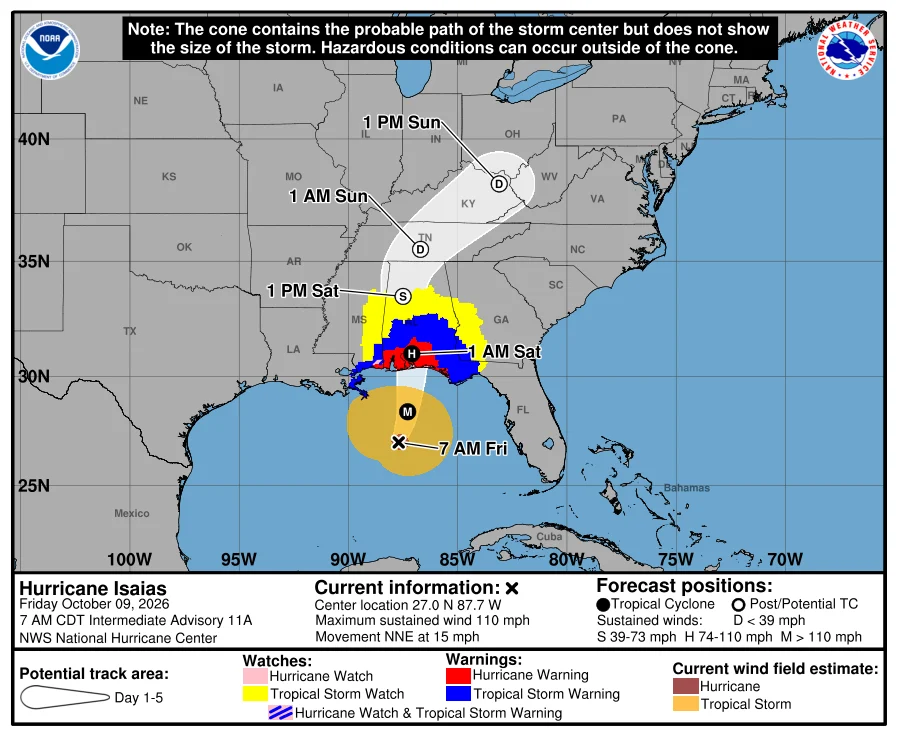
Landfall is anticipated for late tonight, between Gulf Shores, AL and Santa Rosa Beach, FL, with the latest forecast bringing it ashore as a strong category 2 storm. There remains uncertainty in the landfall intensity of Isaias due to an expected significant increase in wind shear as the storm makes its final approach to the coast.
Additional Verisk solutions are available to support your response to this storm. Through our GEO event intelligence solution, we are currently providing pre-event information, including the predicted path, predicted arrival times, cone of uncertainty, and later, confirmed track and confirmed arrival times, updated daily. We have also released our latest Wind Speed Probability layer as well as a Potential Storm Surge layer highlighting areas that are most likely to be impacted by coastal flooding, along with an Outlook report discussing the forecast and potential impacts. One day post-landfall, GEO will provide an Exposure Layer providing a quick snapshot of the impacted area, followed by a Claims Layer - starting three days post-landfall with updates following - which will provide building level assessments of damage based on aerial imagery and the expertise of our intelligence team.
Likewise, our Weather Solutions team has been providing a forecast wind footprint of Isaias since it strengthened to a tropical storm, refreshed every six hours through landfall, to further support response to this storm. Post-landfall, a final view of the wind footprint, with assimilated wind observations, will be available as well. This suite of Verisk event response solutions can be used together to provide a holistic view of the event across insurance functions, including claims, underwriting, catastrophe and exposure management. They can facilitate claims resource management, notify policyholders, implement underwriting moratoriums, understand total exposure at risk, estimate insured losses, and support communication with stakeholders.
Assuming no significant changes in the forecast, we plan to issue a final set of similar stochastic events for Isaias on Saturday morning, EDT. We will produce custom event sets, an industry loss estimate, and other associated deliverables early next week, either Tuesday or Wednesday.
Please contact your Verisk representative with any questions in this ALERT or any of our additional event response and intelligence offerings.
Pre-Landfall SSEs #2 | Downloads
Posting Date: October 9, 2026, 10:00:00 AM
The information provided herein is strictly confidential and is solely for the use of AIR clients; disclosure to others is prohibited.
Similar Stochastic Event IDs
Note: These lists give event IDs taken from our stochastic catalog that have similar characteristics as the current event.
| Product | File Type | Description | Download |
|---|---|---|---|
| TOUCHSTONE / Re | Excel (xls) | Selected set of stochastic events, with Readme in Excel format |  |
| TOUCHSTONE / Re | CSV (csv) | Selected set of stochastic events, formatted for import into Touchstone/Re | |
Additional Downloads
Note: Additional downloads related to the posting are listed below. Please use the appropriate application to view these files.
| Title | File Type | Description | Download |
|---|---|---|---|
| SSE Track Shapefiles | .zip | Shapefile of the tracks of today's similar stochastic events | |